
What Sinkholes on Your Hill Country Property Mean
Sinkholes on Texas Hill Country property are usually quiet until they are not — voids in the limestone can undermine foundations, wreck septic fields, move floodwater in unexpected ways, and complicate insurance. Here is what karst on your lot actually means for buyers and homeowners.
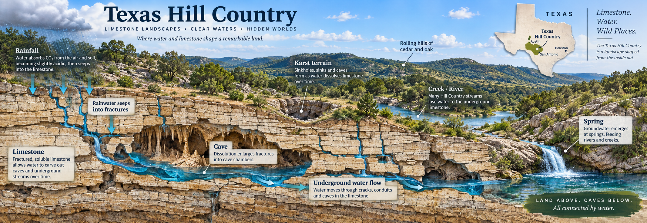
If you've read our guide to Texas foundation problems, you already know the basic geological split in Central Texas: expansive Blackland clay east of I-35, and stable Edwards Plateau limestone to the west. For foundations, that limestone is good news. For almost everything else a Hill Country buyer needs to check — flood risk, septic permitting, well water, what you're even allowed to build — the same limestone is the reason the due diligence list is longer here than almost anywhere else in the state.
This isn't a scare piece. It's the checklist most listing descriptions, and most agents who don't work this specific terrain daily, simply don't walk buyers through. Flood zones and karst geology in the Texas Hill Country interact with each other — the same rock that creates the canyons and swimming holes people move here for is also why water behaves unpredictably both above and below ground.
What Karst Geology Actually Is — and Why the Hill Country Has So Much of It
"Karst" refers to landscape formed when slightly acidic rainwater slowly dissolves limestone bedrock over geologic time, carving out caves, sinkholes, underground channels, and springs. The Texas Hill Country sits on one of the most extensively karst-developed landscapes in the country — the Edwards and Trinity Aquifers are both karst aquifers, and they're the primary water supply for millions of Central Texans.
That's the good part: karst aquifers recharge quickly and produce clean, abundant groundwater. The trade-off is that karst terrain does three things that matter directly to a home buyer:
- It moves water fast, both across the surface and underground. Rain doesn't soak in gradually the way it does in clay or sandy soil — it either sheets off thin, rocky topsoil into creeks and rivers, or drops straight through cracks and sinkholes into the aquifer below.
- It creates voids you can't see from the surface. Caves, solution cavities, and sinkholes form unevenly and aren't mapped parcel-by-parcel. A property can look flat and buildable and still have karst features that limit where you can put a structure, septic field, or pool.
- It's regulated. Because the same cracks and sinkholes that make karst interesting also provide a direct path for surface contamination to reach the drinking water supply, both the state and local counties place real restrictions on construction in karst-sensitive zones — covered below.
Sinkholes on Texas Hill Country Property: Risks for Homeowners
Karst is not just a science term on a brochure. On a Hill Country lot, voids in the limestone under your feet can create real, expensive problems — some of them slow and quiet, some of them sudden. If you already own the property, or you are about to close, these are the risks worth taking seriously.
Ground movement and structural damage
When soil and rock collapse into an underground void, you get a sinkhole — or a slower settlement that shows up as cracks in slab, brick veneer, drywall, or driveway. Not every crack means a sinkhole is opening, but unexplained settlement, doors that suddenly stick, or new exterior cracks after heavy rain are reasons to bring in a geotechnical engineer, not just a handyman. Repairing a foundation or regrading a failed pad on limestone can run far beyond a normal cosmetic fix.
Sudden collapse risk (rare, but not theoretical)
Most karst issues in Central Texas show up as drainage problems, septic failures, or gradual settlement — not dramatic movie-style collapses. That said, cover-collapse sinkholes do occur in Edwards Plateau terrain when soil arches over a void and then fails, sometimes after intense rainfall. Pools, sheds, driveways, and livestock pens have been damaged when voids opened under them. Walk the property after storms; note any new depressions, circular cracks, or places where water disappears into the ground unusually fast.
Water in places you do not want it
Fractured limestone moves water quickly. That can mean flooding that arrives faster than the FEMA map suggests, water under the slab after a deluge, or a wet crawlspace even when the house sits "above" the mapped floodplain. It also means contaminants on the surface — septic effluent, fertilizer, oil from a driveway — can reach groundwater more easily than on clay soils. That is why recharge-zone rules exist, and why a failing septic on karst is both a health issue and a regulatory problem.
Septic, well, and insurance headaches
Thin soil over rock often means a conventional drain field will not perk. You may need an engineered OSSF, a larger field, or a site redesign — sometimes after you have already bought the lot. Private wells can lose yield or draw turbid water when nearby voids redirect flow. Standard homeowners insurance frequently excludes sinkhole and earth-movement losses; flood insurance is a separate policy and still may not cover every karst-related water claim. Ask your insurer in plain language what is covered for earth movement, collapse, and flood before you waive your option period.
What to do if you suspect a problem
Homeowner action list
- Document — photos of cracks, depressions, and ponding dated after storms.
- Call a geotechnical engineer familiar with Edwards Plateau karst — not only a general contractor — if settlement or a new void appears.
- Check permits — unfinished WPAP / OSSF issues can block repairs or additions.
- Review insurance — earth movement, collapse, and flood endorsements or exclusions in writing.
- Before buying — option-period geotech or at least a serious site walk plus septic evaluation on any well/septic acreage.
The Edwards Aquifer Recharge, Contributing, and Transition Zones
This is the piece of Hill Country due diligence that catches the most buyers off guard, because it isn't visible on a drive-by and rarely comes up until a permit application stalls.
The Texas Commission on Environmental Quality (TCEQ) and the Edwards Aquifer Authority (EAA) jointly regulate three overlapping zones across Comal, Hays, Bexar, Medina, Uvalde, Kinney, Travis, and Williamson Counties:
The Three Regulated Zones
Recharge Zone — where Edwards limestone is exposed at or near the surface and water infiltrates directly into the aquifer through cracks, sinkholes, and caves. Construction here faces the strictest review: TCEQ requires a Water Pollution Abatement Plan (WPAP) for most development, along with stormwater controls to keep pollutants from reaching the aquifer.
Contributing Zone — the upstream watershed that drains toward the Recharge Zone. Less strictly regulated than the Recharge Zone itself, but still subject to TCEQ water-quality rules for larger developments.
Transition Zone — areas with faults and fractures that can create additional pathways for surface water to reach the aquifer, regulated similarly to the Recharge Zone in many counties.
What this means in practice: building a home, adding a driveway, clearing significant vegetation, installing a septic system, or even certain fencing and grading work on Recharge Zone property can require a TCEQ-reviewed plan before you break ground. Some counties layer their own additional rules on top. None of this is disclosed on a standard listing — you have to look it up.
How to check: TCEQ maintains an interactive map viewer for Edwards Aquifer Protection zones, and the EAA publishes regulatory zone maps by USGS quadrangle. Before writing an offer on any Hill Country acreage — especially anything you plan to build on, add to, or subdivide — verify the exact zone designation for that parcel. Don't rely on "it's probably fine because the house next door didn't have issues"; zone boundaries can split a single property.
Septic Systems on Karst: The Issue Most Buyers Never See Coming
If a property isn't on a municipal sewer line — common across rural and semi-rural parts of Comal, Kendall, Hays, and Blanco Counties — it needs an On-Site Sewage Facility (OSSF), what most people call a septic system. On karst terrain, this is where septic system Edwards Aquifer Texas rules genuinely change the math on a purchase.
Comal County's own OSSF permit application asks the site evaluator to answer directly: "Is the property located over the Edwards Recharge Zone?" If the answer is yes, the planning materials must be completed and signed by a Registered Sanitarian or Professional Engineer — not just a standard site evaluator — and if there's no existing TCEQ-approved Water Pollution Abatement Plan for the property, one may be required before a septic permit can be issued at all.
Why This Matters at Closing
A septic system that requires WPAP approval takes materially longer to permit than a standard system, and the site evaluation itself can rule out portions of a lot as unsuitable for a drain field — the same karst features (thin soil over fractured limestone) that make the property scenic are often the reason the buildable septic area is smaller than the acreage suggests. If you're buying acreage that doesn't perc or hasn't been evaluated, get the septic site evaluation done during your option period, not after.
This same karst sensitivity is part of why private well water quality deserves its own scrutiny in these areas — karst aquifers move water (and anything dissolved or suspended in it) quickly, with less natural filtration than sand or gravel aquifers provide. A private well on Recharge Zone property should be tested, not assumed clean because the water runs clear.
FEMA Flood Zones in the Hill Country: Why the Map Isn't the Whole Story
The Texas Hill Country's combination of thin soil over limestone, steep terrain, and the Balcones Escarpment's orographic effect on incoming Gulf moisture has earned it a name among hydrologists: Flash Flood Alley. Rainfall that would soak into deeper soils elsewhere sheets off the rock and funnels into narrow river valleys fast — which is exactly what drove the catastrophic Guadalupe River flooding in July 2025, and a larger — but far less deadly, thanks to expanded warning systems — flood event across a wider swath of the Hill Country in July 2026.
Two facts matter for buyers evaluating FEMA flood zone Hill Country Texas risk specifically:
1. Many Hill Country FEMA flood maps are old
Effective Flood Insurance Rate Maps (FIRMs) for several Hill Country counties date back well over a decade — Kendall County's current effective map dates to 2010. FEMA released preliminary updated maps for Kendall, Bandera, Bexar, Kerr, and Medina Counties for public review beginning in January 2025, but until those are formally adopted, the older maps still govern insurance requirements and lending decisions. A property can be accurately mapped as low-risk today and still sit somewhere that would be reclassified once updated data is finalized.
2. The map measures a statistical chance, not a Hill Country flash-flood scenario
FEMA's "1% annual chance" (100-year) floodplain designation is a useful baseline, but flash flooding on karst terrain can move water into places the mapped floodplain doesn't fully capture — a pattern flood researchers have specifically flagged since the 2025 event. Zone designation should be one input into your decision, not the whole due-diligence process.
Practically, that means: pull the current FEMA flood zone for the specific parcel (not the general area), ask directly whether preliminary remap data exists for that county, review the property's flood claim and flood history disclosure, and walk the lot's drainage and grading yourself if you can — ideally after a rain. If a property backs to a creek, sits in a low-lying draw, or is anywhere near the Guadalupe, Blanco, Pedernales, or Comal River systems, get a flood insurance quote before your option period ends, not after you've waived it.
A Practical Due Diligence Checklist
Before You Write an Offer on Hill Country Acreage or a Rural Lot
- Check the Edwards Aquifer zone designation for the exact parcel via TCEQ's map viewer or the EAA's regulatory zone maps — Recharge, Contributing, Transition, or none.
- Pull the current FEMA flood zone for the parcel, and ask the county or a flood-zone specialist whether a preliminary remap is pending.
- If there's no sewer connection, get an OSSF site evaluation during your option period — confirm buildable drain field area and whether a WPAP will be required.
- If there's a private well, test the water — bacteria, nitrates, and hardness at minimum — rather than relying on visual clarity.
- Ask about karst features directly — known sinkholes, cave entrances, or solution cavities on the property or immediately adjacent to it.
- Get a flood insurance quote before you waive your option period, especially on anything near a river, creek, or low-lying draw.
- Confirm buildable acreage, not just total acreage — steep slopes, floodplain, easements, and karst features can all shrink what you're actually able to build on.
Community Notes: Where This Comes Up Most
New Braunfels
Straddles the Balcones Escarpment — western neighborhoods sit on Edwards limestone with karst-zone considerations, while the Comal and Guadalupe Rivers running through town make flood-zone verification essential for riverside and low-lying properties regardless of which side of the escarpment you're on.
Boerne
Sits well within Edwards Plateau limestone country — Recharge and Transition Zone considerations are common on acreage properties, particularly toward Cordillera Ranch and the Guadalupe River corridor.
Wimberley
Karst topography is visible throughout — Jacob's Well and Blue Hole are both karst spring features. Much of the area sits within Edwards or Trinity Aquifer zones, and Cypress Creek and the Blanco River both carry real flash-flood risk during heavy rain events.
Canyon Lake
Waterfront and near-waterfront properties require flood-zone verification as standard practice, and much of the surrounding acreage sits over Trinity Aquifer karst terrain — septic and well due diligence matters as much as the view.
Fredericksburg
Further into the Edwards Plateau, with extensive limestone karst and working ranches on well and septic systems — buyers looking at acreage here should treat the septic and water due diligence steps above as non-negotiable, not optional.
Dripping Springs
West of Austin on the Edwards Plateau edge — acreage buyers commonly hit Recharge or Contributing Zone rules, private-well and septic due diligence, and creek-drainage flash-flood questions that a city lot in Travis County rarely raises.
Bulverde
Hill Country north of San Antonio on Edwards limestone — many tracts sit over karst with well/septic systems, so zone maps and OSSF site evaluations matter as much as school and commute checks.
Spring Branch
Guadalupe River / Canyon Lake corridor acreage where flood-zone verification and Trinity/Edwards karst septic permitting often show up together — pull both before you waive the option period.
Frequently Asked Questions About Hill Country Flood Zones and Karst Geology
What is karst geology and why does the Texas Hill Country have so much of it?
Is limestone a stable foundation but a flood risk at the same time?
What is the Edwards Aquifer Recharge Zone and how does it affect buying a home?
Why is septic permitting harder on Edwards Aquifer property?
Are FEMA flood maps accurate for the Texas Hill Country?
What should I check before buying acreage in the Hill Country?
This article is for general informational purposes and does not constitute geotechnical, environmental, legal, or engineering advice. Aquifer zone designations, flood zone maps, and septic requirements are subject to change and vary by exact parcel. Always verify current regulatory status directly with TCEQ, the Edwards Aquifer Authority, your county's environmental health department, and FEMA before making purchase or construction decisions, and consult licensed professionals for property-specific assessments.