Updated August 26, 2026

A Lost Pines river town on Austin's fast-growing eastern edge
Moving to Bastrop puts you in a Lost Pines river town on Austin's fast-growing eastern edge — not another I-35 suburb. Bastrop is the seat of Bastrop County, a city of roughly 13,383 (the surrounding ZIP 78602 and the county are far larger) on SH-71 and US-290 about 30 miles southeast of Austin. It sits on the Colorado River in the Lost Pines, and anchors one of the fastest-growing counties in the country.
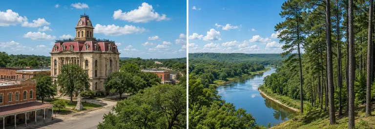
Bastrop is not an I-35 town. It sits southeast of Austin where SH-71 and US-290 meet the Colorado River, inside the Lost Pines — an isolated stand of loblolly pine that gives the area a look found nowhere else in Central Texas. The 27-block downtown historic district holds 131 National Register sites, including the 1889 Bastrop Opera House, and the Old Iron Bridge still carries traffic across the river.
The economic story now runs on two tracks. The old one is tourism and the river: the Hyatt Regency Lost Pines resort, state parks, and a walkable downtown of cafes and shops. The new one is the tech-and-industrial buildout spreading east from Austin — new manufacturing, logistics, and supply-chain employers — plus the Austin–Round Rock job market a commute away.
Growth here is real and fast. Bastrop County grew from 74,171 residents in 2010 to a July 2025 estimate of 118,908 — a 22.3% jump just since 2020. The city of Bastrop itself grew 38.2% over the same five years. Most of that growth is landing in master-planned subdivisions in the unincorporated ring around the city, not the old city core.
Three buyers drive this market: relocation buyers researching the eastern-Austin job corridor, current owners tracking a market that has stabilized after the 2021–22 run-up, and longtime residents who follow downtown, the river, and the Lost Pines. This page is built for all three — and everything on it is sourced to primary records you can check yourself.
1 · School assignment. Bastrop ISD campuses range from A to F. Your elementary and middle school depend on the exact address — and 2026–27 middle-school zones were redrawn. Confirm the campus at the address, not by what's nearest.
2 · MUD tax rate. Master-planned neighborhoods (The Colony, Adelton) sit in Municipal Utility Districts that add roughly $0.85–$1.00 per $100 on top of county and ISD. Confirm the combined rate for the specific lot.
3 · Wildfire & flood. Bastrop County carries a high wildfire risk profile and river-adjacent flood exposure. Check First Street and NFIP requirements for the address before you write.
The 78602 median sits at $381,515 (single-family, June 2026), up 3.1% year over year — a market that has stabilized, not fallen, after the 2021–22 surge. Days on market have lengthened, so buyers have more room to negotiate than they did two years ago.
The variable that moves your monthly cost most here isn't the list price — it's the MUD. A home in a Municipal Utility District can carry a combined tax rate near 2.5%, versus roughly 2.0% for a non-MUD Bastrop address. Confirm the district before you fall for the sticker price.
Where to Live
Adelton
Bastrop ISD's newest namesake subdivision, zoned to Adelton Elementary (TEA: B, opened Aug 2025) → Bastrop MS (B) → Bastrop HS (B) — the cleanest B/B/B feeder chain in the market. New construction. Note the tax stack: Adelton sits in West Bastrop Village MUD at $1.00/$100, pushing the combined rate near 2.5% before homestead exemptions. Verify your campus and MUD rate at the address.
The Colony
The largest master-planned community in Bastrop (Hunt Communities; builders include Perry, Lennar, M/I, David Weekley, Ashton Woods). Main body zones to Colony Oaks Elementary (TEA: B) → Bastrop MS (B) → Bastrop HS (B). The Colony sits across several MUD sub-districts (#1A–1G) with 2025 rates of $0.665–$0.85/$100 — verify your section. Northern/Riverside sections may zone differently; confirm at the address.
Circle D-KC Estates
An established east-side subdivision known for larger lots, mature trees, and a quieter footprint than the production-builder corridors. Zones to Lost Pines or Emile Elementary depending on the exact lot (both TEA: F) → Riverside MS (D) → Bastrop HS (B). A value-and-space buy where schools matter less than acreage — verify the campus at the specific address.
Tahitian Village
Bastrop's largest established subdivision — roughly 1,600 deed-restricted lots along the Colorado River with pine-shaded character, an 18-hole golf course, and clubhouse. It predates the current growth wave by decades and trades on established trees and river access over new construction. Zones to Emile Elementary (TEA: F) → Riverside MS (D) → Bastrop HS (B); weigh the character against the campus ratings.
Pecan Park
A mixed-use development inside Bastrop city limits with city services and walkable access to local attractions — a practical fit for buyers who want newer construction on an in-city footprint rather than the broader master-planned rings. Zones to Mina Elementary (TEA: D) → Riverside MS (D) → Bastrop HS (B). Confirm your exact block, as the western edge can shift zones.
Downtown Historic District
Bastrop's 27-block downtown historic district — 131 National Register sites along Main Street and the Colorado River, the 1889 Opera House, the courthouse square, and walkable access to the river and cafes. A character-and-walkability buy, not a schools play: it zones to Mina Elementary (TEA: D) → Riverside MS (D) → Bastrop HS (B). The most authentic "Bastrop for Bastrop" address you can hold.
The Reference Desk
1 · The growth engine. Bastrop County grew from 74,171 residents in 2010 to a July 2025 estimate of 118,908 — a 22.3% jump just since 2020 — making it one of the fastest-growing counties in the country. The city itself grew 38.2% over the same five years. Most of that growth is landing in master-planned subdivisions in the unincorporated ring: The Colony (Hunt Communities), Adelton (Bastrop ISD's newest namesake), and production-builder product east of Austin.
Source. Redfin put the ZIP 78602 median sale price at $381,515 for single-family homes as of June 2026, up 3.1% year over year (All Home Types tracked within $461 at $381,054). We use the ZIP-level figure because the city limits are small and most buyer activity sits in the surrounding 78602 ring. Monthly figures move and submarkets vary, so verify at the address.
2 · The MUD nuance. The variable that moves your monthly cost most here isn't the list price — it's the Municipal Utility District. Adelton sits in West Bastrop Village MUD at $1.00/$100; The Colony's sub-districts (1A–1G) run $0.665–$0.85/$100. Stacked on the county rate ($0.428710) and Bastrop ISD ($1.0679), a MUD address can carry a combined rate near 2.5%, versus roughly 2.0% for a non-MUD Bastrop home. Builder "low tax rate" language refers to the base rate before the MUD is added.
3 · The market has stabilized, not fallen. The +3.1% ZIP-level figure reflects a balanced market that normalized after the 2021–22 surge — days on market have lengthened, giving buyers more negotiating room. County-wide medians show larger year-over-year declines, but that reflects Elgin and Smithville dragging the aggregate, not the Bastrop core.
Typical housing stock. Master-planned new construction (The Colony, Adelton, Pecan Park) in the growth ring, established river-side subdivisions like Tahitian Village, larger-lot east-side acreage in Circle D-KC, and the 27-block downtown historic district. Retirees weighing a move can read Relocating to Texas as a Senior.
Which county is Bastrop in? See our Central Texas towns by county, ZIP code and population guide.
Bastrop is not on I-35. The spine is SH-71 (the main Austin artery, northwest to ABIA and downtown) and US-290 (northeast toward Elgin). SH-21 runs southwest toward San Marcos. Transit is limited: rideshare citywide, no commuter rail. Most households run two cars; the ACS mean commute is 30.0 minutes for the city, 35.4 for the county.
The economy runs on two tracks: the established tourism-and-river base (the Hyatt Regency Lost Pines resort, state parks, a walkable downtown) and the newer tech-and-industrial buildout spilling east from Austin. Verify current employer figures directly; the growth sector is moving fast.
Bastrop has grown its local health footprint, with major hospital systems and Level I trauma care in Austin roughly 35 minutes northwest via SH-71. Confirm current facility names and services before relying on them — the local medical sector is expanding with the population.
H-E-B anchors local grocery, with Walmart and the SH-71 retail corridor (including Buc-ee's) covering everyday needs. Downtown Bastrop's Main Street handles boutique and specialty shopping. For big-box and mall retail, Austin's southeast side is roughly 25–35 minutes northwest.
City-contracted service inside Bastrop city limits; unincorporated Bastrop County and master-planned communities are private contract or MUD-provided. Look up your service by address — MUD neighborhoods often bundle utilities differently from the city.
Downtown Bastrop's historic district holds the local dining core — cafes, the Neighbor's Kitchen and Yard, Maxine's Cafe & Bakery, and river-adjacent spots along Main Street. The Colorado River, the Old Iron Bridge, and the Lost Pines set the scene. Verify hours seasonally; downtown draws heavily on weekends and during events.
Bastrop State Park and Buescher State Park (connected by Park Road 1C through the Lost Pines) anchor the outdoor scene, plus Colorado River access and the ColoVista and Pine Forest golf areas. Boarding and vet services are locally served, with overflow into Austin.
Inside city limits, the City of Bastrop and Bluebonnet Electric Cooperative handle core services; MUD neighborhoods (Adelton/West Bastrop Village, The Colony) provide water and wastewater through the district, which is why the tax stack is higher. Gas, and internet (fiber availability varies) depend on the specific address — verify before you close.
New Texas residents transfer registration and license within 90 days. The Bastrop County Tax Assessor-Collector (Ellen Owens) handles vehicle registration and property tax; Texas DPS runs a local driver license office. County records and courts sit at the historic Bastrop County Courthouse (1883); property values at the Bastrop Central Appraisal District.
Bastrop's identity is river-and-pine: the only Lost Pines town on the Colorado River, with a 27-block historic downtown that predates the growth wave by more than a century. The character survived because the river, the state parks, and downtown gave the city an anchor that the master-planned rings build around rather than erase.
The Lost Pines
An isolated stand of loblolly pine — a remnant forest found nowhere else in Central Texas — that gives Bastrop a look closer to East Texas than the Hill Country. Bastrop and Buescher State Parks preserve the heart of it, connected by the scenic Park Road 1C.
The Colorado River
The river runs straight through downtown, crossed by the historic Old Iron Bridge. Paddling, fishing, and riverfront parks anchor the outdoor scene, and river-adjacent addresses (Tahitian Village, downtown) carry a character premium.
Downtown Historic District
A 27-block district with 131 National Register sites along Main Street, including the 1889 Bastrop Opera House, the Old Iron Front building, and the courthouse square. Walkable cafes, shops, and river access make it the most authentic address in town.
Hyatt Regency Lost Pines
A destination resort on the Colorado River in the Lost Pines — golf, a lazy river, and a spa — that anchors the area's tourism economy and draws visitors (and visiting family) year-round.
State parks & golf
Bastrop State Park's historic CCC-built cabins and pool, Buescher's quieter lake, and golf at ColoVista and the Pine Forest course. The 2011 Complex Fire reshaped the pines; recovery is visible and ongoing across the parks.
The eastern-Austin edge
What's new is the tech-and-industrial buildout spreading east from Austin — new manufacturing, logistics, and supply-chain employers, with Tesla's Giga Texas roughly 30 minutes northwest. It's reshaping who moves here and why. Verify current named employers before relying on any single one.
We publish only real, attributable, consented resident stories — not stock testimonials. If you live in Bastrop and want to share what moving here was actually like, we'd like to hear it.
Bastrop Preferred Partners
We are building a vetted local network for new and relocating residents. No filled partner cards are currently listed for Bastrop.